Yer humble host made a trip down to "the home" this weekend, and lo and behold the locals were yet again celebrating their city.
In this case LEO, Louisville's version of City Paper, had a lengthy article on shotgun houses, with profuse photography....worth a surf to see the kind of media Dayton vernacular architecture doesn't get...
Southern Standard- A Loving Defesne of the Shotgun House
..which included this sidebar on the Anatomy of a Shotgun House
While we see superficial articles on Rehabarama and what-not not once have I saw a journalistic attempt to explain the local vernacular architecture in Dayton, similar to this. In fact smaller houses akin to Louisville shotguns are written off as throwaways, just more fodder for vacancy and abandonment and demolition.
As for popularity, the article makes a point that these houses are seeing renewed interest:
This is ostensibly a defense of the shotgun house, although I’m not sure that concept is in need of protection: Once popular for their pure economy, shotguns seem to be experiencing a resurgence here. This is in part a fad driven by lust for the doggedly nostalgic. But there is also something more legitimate, something having to do with the idea that shotguns are perhaps the cheapest, easiest way to buy into the extraordinary history of the River City and its buildings.
Imagine that, people wanting to buy-in to the history of their city, and a houseform associated with that history. Probably unfair to compare Dayton, since the place really has no history as far as the locals are concerned, beyond the history of certain local corporations, industrialists, and aviation.
Amazingly enough this houseform is seeing a revival in new construction, the caption to the following pix reads:
"The Sienna II, a newly constructed camelback in the Norton Commons development. According to Marilyn Osborn, an event planner there, as many as 50 of the 240 houses currently standing in the mixed-use development are variations on the shotgun design."
Again, can anyone imagine Dayton builders basing new suburban houses on trad 19th century housing found in Dayton city? To consider Dayton's trad city houses worthy of emulation?
I didn't think so.
In any case, its always great to get back to Louisville, a city that actually values and celebrates its everyday vernacular architecture, the fabric of a city that gives a place it's character, to the point of even having a sort of block party or festival about it:
Germantown Shotgun Festival
Sunday, June 29, 2008
Wednesday, June 25, 2008
Eurosprawl II: Nazi Suburbia
Housing is the building block of suburbia, in Germany as in the US. Both countries have their own specific generic postwar houseforms. Here is a speculation on possible NS-era origins of the German suburban vernacular.
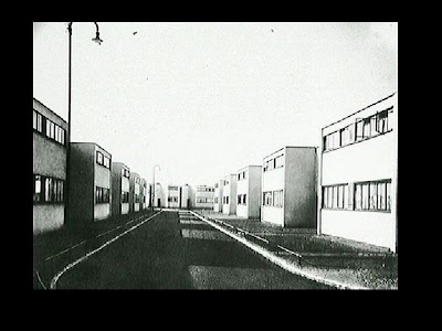
The Weimar Republic was a pioneer in modern housing solutions via the [i]siedlung[/i], or housing project. Functional and spartan housing complexes based on ostensible rational design in the service of a notional socialist political economy. Good example is the Torten siedlung outiside of Dessau, in Anhalt province...
...functional and basic, but very cold.
This was anathama to the culturally conservative National Socialists. Ironically their Fascist brethren in Italy were big fans of modern architecture, appreciating its modern and futuristic quality.
Nazi Germany, though futuristic and modern in some ways, was at heart about ethnolinguistic nationalism run amok and "traditional values", including traditional aesthetic values.
The functionalist comprehensive planning concepts of the Wiemar-era siedlung were appropriated, but the housing took on a somewhat traditionalist form, with sloping roofs and regular windows, including some vestigal traditiongalist detailing, as in this example....
...replace the sloped roofs with flat and the windows with band windows and this would be a fairly good modernist development.
After the war, during reconstruction and later, one saw modernist housing (which was what was advertised outside of Germany), to show that the new FRG was au-courant, making a break from the NS past.
Yet perhaps more common, though less publiciszed, was the persistance of the NS-style trad forms for mass housing, as a more realistic solution for a country that was mostly in rubble and having to resettle a large refugee population.
Example is this postwar DP colony north of Frankfurt. One can see the retention of the houseforms from the NS era, including little shutters on the windwos.
...and perhaps a more moderinizing example, particularly in the window details:
(Siedlung Kreuzberg, outside of Bad Vilbl, northern suburb of Frankfurt)
Sources for the NS housing aesthetic
One can speculate a bit on where the Nazis were getting their style from. Could it be as simple as the generic German half timbered house. These used to be whitewash and black paint on the wood, so a very stark minimal style...
...take away the timbering, and perhaps rationalizing the window arrangements, and one has a good start at a modern version of a vernacular German houseform.
Another source is the high-design architecture of the era prior to the NS takeover, going as far back as the Arts and Crafts movement. In the US this led to the bungalow. In England there was CR Macintosh and especially CFA Voysey, who employed a very simplified trad style based on cottages and old manor houses.
In Germany there was Heinrich Tessenow, who designed in a stripped classical manner, but combined it with a sort of cottage aesthetic. Perhaps Tessenow was a big influence on NS housing designer.
Heres an example. On the left, two Tessenow designs. On the right an NS housing development in the Saarland.
One can see a strong aesthetic affinity, particularly in the gable treatment of the upper example
Another example of NS housing in the Saarland. This could almost be mis-dated for postwar German suburbia...
...white stucco , normal windows, gable roof. The difference in modern German suburbia is the houses are bigger and somewhat more elaborate in detail, as in this example from north of Frankfurt...
As we know the postwar FRG developed into an exemplary social democratic welfare state. Though they rejected the racist nationalism and militarist expansionism of the NS era, the Germans retained a fondness for trad-derivied housing styles in suburbia. Yet suburban house style never did move into literal revival architecture the way American house construction did.
Next, a look at modern Eurosprawl in the Frankfurt region.
The Weimar Republic was a pioneer in modern housing solutions via the [i]siedlung[/i], or housing project. Functional and spartan housing complexes based on ostensible rational design in the service of a notional socialist political economy. Good example is the Torten siedlung outiside of Dessau, in Anhalt province...
...functional and basic, but very cold.
This was anathama to the culturally conservative National Socialists. Ironically their Fascist brethren in Italy were big fans of modern architecture, appreciating its modern and futuristic quality.
Nazi Germany, though futuristic and modern in some ways, was at heart about ethnolinguistic nationalism run amok and "traditional values", including traditional aesthetic values.
The functionalist comprehensive planning concepts of the Wiemar-era siedlung were appropriated, but the housing took on a somewhat traditionalist form, with sloping roofs and regular windows, including some vestigal traditiongalist detailing, as in this example....
...replace the sloped roofs with flat and the windows with band windows and this would be a fairly good modernist development.
After the war, during reconstruction and later, one saw modernist housing (which was what was advertised outside of Germany), to show that the new FRG was au-courant, making a break from the NS past.
Yet perhaps more common, though less publiciszed, was the persistance of the NS-style trad forms for mass housing, as a more realistic solution for a country that was mostly in rubble and having to resettle a large refugee population.
Example is this postwar DP colony north of Frankfurt. One can see the retention of the houseforms from the NS era, including little shutters on the windwos.
...and perhaps a more moderinizing example, particularly in the window details:
(Siedlung Kreuzberg, outside of Bad Vilbl, northern suburb of Frankfurt)
Sources for the NS housing aesthetic
One can speculate a bit on where the Nazis were getting their style from. Could it be as simple as the generic German half timbered house. These used to be whitewash and black paint on the wood, so a very stark minimal style...
...take away the timbering, and perhaps rationalizing the window arrangements, and one has a good start at a modern version of a vernacular German houseform.
Another source is the high-design architecture of the era prior to the NS takeover, going as far back as the Arts and Crafts movement. In the US this led to the bungalow. In England there was CR Macintosh and especially CFA Voysey, who employed a very simplified trad style based on cottages and old manor houses.
In Germany there was Heinrich Tessenow, who designed in a stripped classical manner, but combined it with a sort of cottage aesthetic. Perhaps Tessenow was a big influence on NS housing designer.
Heres an example. On the left, two Tessenow designs. On the right an NS housing development in the Saarland.
One can see a strong aesthetic affinity, particularly in the gable treatment of the upper example
Another example of NS housing in the Saarland. This could almost be mis-dated for postwar German suburbia...
...white stucco , normal windows, gable roof. The difference in modern German suburbia is the houses are bigger and somewhat more elaborate in detail, as in this example from north of Frankfurt...
As we know the postwar FRG developed into an exemplary social democratic welfare state. Though they rejected the racist nationalism and militarist expansionism of the NS era, the Germans retained a fondness for trad-derivied housing styles in suburbia. Yet suburban house style never did move into literal revival architecture the way American house construction did.
Next, a look at modern Eurosprawl in the Frankfurt region.
Friday, June 20, 2008
Downtown Plaza & K Street
Like everywhere else Sacramento's downtown retail declined and fell with the rise of postwar suburbia. Unlike Dayton, there wasn't that big urban fear that prevented people from taking a second look and returning downtown when things changed.
Sacramentans don't fear & avoid their city the way Daytonians do.
So a look at the revival of downtown retail and the old K Street shopping district.
When last we saw Sac we were looking down a street in Old Sac toward downtown. That street is taken down under the interstate via this underpass, which isnt as grim as you'd imagine as it is very well maintained, and has murals and stuff, including one by the Royal Chicano Air Force...
Popping out on the other side one ascends a landscaped ramp/walkway to the Downtown Plaza shopping mall.
(this sequence... Old Sac/underpass/ascent... is actually fairly sucessfull as a lot of care was taken in designing it).
Downtown Plaza was originally a smallish outside shopping center sitting on top of a parking garage (free parking on Saturdays...smart move). Anchors where Macys California, I Magin, and the local Weinstocks department store, which was a full service store, sort of a larger version of Dayton's old Elder Beerman).
Sometime after 1988, probably in the early 1990s, it was drastically redesigned and expanded, and a downtown movie theater was added. By this time Weinstocks and I Magin had folded, and Macys took over the Wieinstock space for an additional store.
Architecturally the place has a sort of LA-modern thing going on (sort of a pop version of Morphosis)....
Lots of attention to detail to make the place visually interesting, with space broken into outdoor rooms/squares and streets.....
After passing east through the Downtown Plaza one arrives at the old shopping street, K Street.
This was turned into a pedestrian mall, with a lot of decorative concrete, referred to by the locals as "tank traps". This failed, and when light rail came, K Street was redesigned as a tree lined transit mall.
Some vignettes of K Street, the verticle one on the left looking west, and the lower right one showing that there is still a lot of vacant space on this street. The upper right one shows that adaptive reuse and rehab is also happening along with new construction.
But there still is a bit of retail to keep the place somewhat alive, including a used record store, variety stores, drug stores, little stores serving the Latino market (a bit like downtown LA there), and the great old Crest Theatre with its wonderful neon sign.
("Ban Roll-On Building" in the backrground)
Wednesday, June 18, 2008
Eurosprawl I: Allotments
The first of a short series of posts on Eurosprawl, how the Europeans (pretty much just the Germans) do suburbia. A lot of this will be personal observation based on what yer humble host knows, remembers, or finds on the ‘net.
First a look at allotments, kicked off by some discussion over at Dayton Most Metro.
In German speaking lands these are called Schrebergarten (after the originator of the concept, Dr Schreber) or Kleingarten (literally “small gardens”).
A good pix here of the traditional Schrebergarten, most of the surface under cultivation, high fences, some ornamental flowers, vines.
The idea was for apartment dwellers and factory workers to grow their own food as well as sort of a form of recreation. A reaction to the consequences of industrialization and mass housing in cramped urban quarters.
This concept actually took off, and gardening became popular, resulting in scherbergartening becoming a part of German popular culture. Since the Germans build at high density, even after the war and into the mass auto ownership era, these remain popular as a way of getting a little yard space.
This miniature diorama is a good illustrations showing some typical features…the rustic Jagerzaun (“hunters fence”…these are found all over, though), the potting shed, working on seed beds, watering gear, etc
The idea was for apartment dwellers and factory workers to grow their own food as well as sort of a form of recreation. A reaction to the consequences of industrialization and mass housing in cramped urban quarters.
..and sometime garden colonies can be quite large, like this one in northern Germany. One thing that separates this concept from the US-style community garden is that one rents ones own plot, which are usually larger than a community garden plot, and the plots are usually fenced. So one has a colony of private plots, each with their own personality.
Some typical Schrebergarten scenes…the last one showing some typical German suburbia in the background (this is near Frieburg in Baden-Wurttenburg, AKA “the Black Forest”)
One thing that’s noticeable in the recent past is the change in German society to a US-style consumer culture has led to the transformation of the more ag-production concept of the Schrebergarten to the Freizeitgarten, literally “Free Time Garden”, or “Leisure Garden.
This means more lawns and flowers, more elaborate landscaping, more life-like garden gnomes, and especially the transformation of the potting shed into a little cottage.
From Schrebergarten to Dacha?
The apotheosis is the transformation of the Schrebergarten into a US-style backyard, as in this digital rendering:
But with the rise of green trend, things like slow food, sustainability, low carbon footprint, etc. there is a new hipster interest in urban farming and sustainable agriculture, ensuring that the allotment tradition of small scale ag production continues
Allotments are a picturesque part of the European suburban scene, at least in German-speaking lands, but would they work on this side of the pond, where we have plenty of yard space?
Sunday, June 15, 2008
Old Sac
Old Sacramento is where the city meets the river, the old steamboat landing . Symoblic of this is the packet liner Delta King, restored into a floating hotel. A freight and passenger service of the Southern Pacific railroad, it connected San Francisco with Sacramento and towns along the Sacramento River in the Delta area. In earlier times steamboats continued upriver to Marysville and also up the San Jouquin to Stockton.
Here's a view of old Old Sac. One can see one of the SP/CP trains pulling up along the wharf, and also notice the awnings and canopies over the boardwalk sidewalk, to shield folks from the oppressive summer heat (average temp in the 90s, with 100 degree days no uncommon)
Old Sac started during the gold rush era of 1849, but was rebuilt after a big fire in the 1850s, (the oldest buildings date from the 1850s) . This part of town lost one story on some buildings as the grade was raised here and back into the modern downtown to prevent flooding. This is a very low lying area, at sea level (and below in some parts).
There is a network of tunnels and former first floor spaces that are now basements under Old Sac and the rest of downtown due to the grade raising.
The pix here is of the oldest building in Old Sac. Hastings Bank was the former Pony Express terminus and state Supreme Court chambers on the second floor. This pix shows the building when Old Sac was the one of the largest skid rows on the West Coast. One can see a "bottle shop", employment agency, dry goods, and the "Timber Club" bar.
(you can click on the pix to get the detail)
Since ag in the Central Valley was large scale, from the bonanza farming era down to modern day irrigated fruit and veggy production, it relied on a lot of hired-hand itinerant labor, as did the timber industry up in the Sierra Nevada.
Sacto was the entreeport & base for this migratory labor stream, especially since it was the big inland railroad junction for both the SP and Western Pacific "Feather River Route". Thus a big center for drifters coming in to look for seasonal work. Old Sac was their neighborhood.
Substantially rebuilt and restored during an 1960s urban renewal push, Old Sac is now a popula tourist attraction. I've been told that the tourists here are actually mostly locals and day-trippers from the Bay Area, not so much out-of-towners. Lake Tahoe and the Mother Lode gold country is the destination for out-of-state tourism, with Sac being at best a way-station.
(this is the old Wells Fargo building..restored Hastings Bank to the right).
There are some museums here (a local history museum and the California State Railway Museum, which is one of the best in the US), but I think people just come for the ambience.
Unlike Daytonians, Sacramentans don't seem to have that "urban fear" that keeps them from venturing downtown. And the locals have suburban alternatives to Old Sac in Folsom, which is a renovated old gold rush town as well as suburb (sort of a "Waynesville") .
Yet they continue to visit here, repeatedly, as the place has always been a sucess. Which might also be due to the size and affluence of Sacramento vis a vis Dayton.
You've probably noticed the overhangs and boardwalsk. Very wild west. But they were there in the olden days, as per that period pix above. Here is what they look like.
Definetly an attempt to create a living history/period feel (this is an official State Historic Site), but there are restaurants and even some bars (with music) here. And apartments and offices. So though it looks sort of Disneyland it is an example of a mixed use redevelopment.
Next, we'll follow this street under I-5 to the modern downtown shopping mall and old K Street, the former shopping street of Sacramento.
Thursday, June 12, 2008
Tower Bridge
Probably as much a landmark as the Capital building, the beloved Tower Bridge dominates the riverscape in downtown Sac. This was built in the 1930s to replace an older combination railroad/road bridge that brought the Sacramento Northern interurban into the city from the west.
Tower Bridge, so named for a slight similarity to its namesake in London.
And like the London one, this Tower Bridge is a draw bridge, in this case a lift bridge. Not too common...I think the closest is the 17th Street Bridge over the Ohio in Louisville.
The river in Sac is still navigatable, so the bridge does see occasional use.
One of Sacramentos many nicknames is River City, and it is indeed that, orginally built by the steamboat trade as much as Louisville and Memphis. The city really embraces its rivers, too (the American River, which joins the Sacramento just north of downtown, is clean enough to swim in, though cold from the Sierra meltwater and springs)
The aerial below shows how the bridge interfaces with the city, as well as some local landmarks.
Old Sacramento was the original downtown at the steamboat landing, and is now a tourist spot (more on that later), and the old SP steamship docks at the landing site.
The "Miami Vice Building" (I have no idea what it's really called) of the 1980s, nicknamed after the architecture in the TV series, was the first of the taller commercial skyscrapers, pretty much kicking off the citys high-rise expansion. The Crocker is an old mansion converted to an art museum.
The bridge opens onto M Street, renamed Capital Avenue, and terminates the westward vista on this street, which has been developed as a boulevard leading up to the capital building.
A better view of the vista is in this illustration for a proposed skyscraper. A fittingly grand, amost quasi-baroque boulevard leading up the seat of government of "California Republic", with the capital park in the background....
Unfortunatley this is pretty sterile monumental space, lacking the human scale of a true European allee or boulevard.
Another view of Tower Bridge, this time more toward downtown and Old Sac. The Delta King (sister ship to the Delta Queen) is visible in this pix.
One can see the former expanse SP yards and shops, which will be undergoing redevelopment. Though steamboat trade (and being selected the capitol) was the original impetus for growth it was the railroad, specifically being the terminus for the transcontinental railroad, that really built Sacramento in the 19th century.
Some other highlights...Chinatown Center, once the old Chinatown, now offices, restaurant, and housing. The larger towns in the Delta, along the river south of here, had Chinatowns for the Chinese field and levee workers. Sacto had one too. Of these, the best preserved is Locke.
Union Station is being used for Amtrak trains now (there is pretty agressive Amtrak service in California, which is a bit unexpected given the state's rep for auto centric living. Macys is the downtown dept. store, part of a shopping center we will look at a bit later.
Next up, a visit to Old Sac.
Daytonology Bizzaro World
Yeah, I know, most of you already think this blog is bizzaro world since it's so out of touch with the local zeitgeist, genus loci, whatever.....
..this is a bit different. Some of you might recall those old Superman comics where they used to do everything in reverse, or sort of an alternative universe, called 'bizzaro world'.
For the future a bit yer humble host will explore an urban bizzaro world, a healthy and growing urban area vs Dayton's sick and declining one. And this urban bizzaro world will be Sacramento. A place as unlike Dayton as possible while still staying in the US.
But we will go abroad every so often to visit Eurosprawl. A series of occasional posts inspired by Paul Krugmans recent column about his trip to Germany will explore suburbia in the Frankfurt/Rhine-Main region.
If you really, really must have Dayton content....
<----the blogroll awaits.
Monday, June 9, 2008
Roosevelt High School Demolition
Heading west on US 35 I saw the construction crane over the trees , which was a reminder that Roosvelt High Schol was coming down. Built in the 1920s, I think, this was the big west side high school. It was so big that you can't take pix of it in one shot. There are flanking wings, then it extends back on the lot some.
The lawn reverting to prarie and the abandonded and somewhat ruined wing in the background give a sort of "city or ruins" feel to the place, or maybe some old country house gone to ruin and seed after a revolution and the dispossession of some ancien regime.
The brickwork on this side wall was laid in a diamond pattern decorative bond. It might just be visible if you click on the pix to englarge it.
Looks like the demolition is proceeding apace on this front entrance. Perhaps some ornamental stuff was stripped from that piedment?
Surroundings reverting to nature. With some cropping one can get that "bit of country in the heart of the city" feel since buildings are not that visible around here, except for that big church set in a forest across Third.
I expect we will see more of these urban savannahs as the city ramps up their demolition program.
Apparently there was some historic preservation interest in saving this school, perhaps some nostalgia from old timers. Roosvelt did have historic value, as a monument to local racism.
It was discrimination and poor treatement of black students by Roosevelts' administration and teachers that led black parents to lobby the school board for a separate school for blacks, so they could be given a fair education. The school board agreed to this, and segregated Dunbar High School was formed, with it's own building on Summit Street. I think Dunbar was built in the 1930s.
The old Dunbar School has been torn down, too, but the name lives on in a modern school south of Germantown Street.
Sunday, June 8, 2008
Patterson Schools' Last Days
There is a pretty good little thread going on at Dayton Most Metro on Patterson School.
This was a vocational school built on about a half block downtown, probably in the early 1950s., and will be torn down this summer.
Architecturally it's pretty banal, but is one of those background buildings that are individually pretty average, yet contribute to the urban fabric. In this case the building helped maintain a street wall on First Street, and the design did respect the context to some degree, via the curved corner at First & St Clair.
The First and Jefferson corner was pretty brutal, though. Yet, still, the concrete frame is exposed, adding some visual interest to the blank brick facade.
Though high modernism of this era was very stripped and minimalist, in provincial citys like Dayton things weren't as aesthetically doctrinaire. In this case there actually was an attempt at facade composition and articulation, particularly at the entrance, with the slight bow on the wall with the band windows, done in stone veneer, and the window wall on the stair well.
The composition of the windows isn't too bad either. In some ways this is similar to the lower part of the Talbot Tower.
...and in the background one can see the building's fate: open space. There seems to be some confusion as to whether this will be a parking lot or just a vacant lot with grass ground cover. Whatever the surface treatment, you will be able to see the backs of the following buildings on Second and Jefferson Streets from this angle: Aquarius, the beauty college, Dayton Stencil, and the DVAC building and its neighbor, and maybe the DHC and print shop on Jefferson.