Yer humble host could spend all week blogging about this book. It’s really juicy.
It was written by a journalist, not an academic, so it reads fast and isn’t dry, as academic books can sometimes be.
What’s it about? A cold hard look at the decline of the Midwest. No happy talk or sunny scenarios here. Just a reality check on how economic forces, mostly globalization, but also earlier economic challenges like Japanese imports and work moving South, are changing the region. And how Midwestern values & attitudes don’t help much.
The author is a native Iowan, and he used to be a foreign correspondent for the Chicago Tribune. So Iowa places are frequently featured as examples and case studies. Chicago is also featured as a Midwest place that has found a role as a node in the global economy, as a second tier world city. Other places are also featured, like Beardstown, Illinois (for the impact of Mexicans working in meatpacking), and Grand Rapids and Peoria as smaller cities that are finding a niche in the global economy. Most major Midwest cities get a mention.
A strength of the book is the focus on the rural, small town, and small city Midwest, places like Warsaw, Muncie, and Anderson, Indiana (all discussed in the book). Some of this is probably old news (decline of rural America, factories closed due to foreign competition), some is new, like Peoria as a positive case study for a response to globalization.
There are interesting insights on education, particularly higher education, on how the big land grant universities are becoming disconnected from their states due to funding cuts.. The author suggests that it might be better for these universities to become primarily graduate level schools and research institutions, networking & collaborating with each other, funded by corporate and nonprofit grants, corporate research partnerships, and tuition.
State and local government is castigated as fragmented, parochial, antiquated, and irrelevant. The author calls for a true regional approach to economics and education, suggesting in-state tuition to any Midwest university for Midwestern students. The idea is not outlandish as there has been a form of this in the South for decades. An example is the agreement between Kentucky and West Virginia, where students from WVA can go to college at U of K paying in-state tuition if WVU doesn’t offer the program.
The author also makes the point that Midwesterners don’t value education, particularly college, and this is a historic shift.
I agree with this as I can offer anecdotes from co-workers who don’t really care if their kids go to college, that if they want to go its up to the kid to pay for it (from people who could easily help out with their kids tuition). I recall similar attitudes from people I went to high school with in Louisville.
What’s new news is that it’s white Midwesterners who hold this attitude the most. People stereotype black folk as ghetto, but the author cites a Michigan study showing that more blacks think a college education is essential to get ahead than whites.
Yet the author writes about the blacks, a lot of them, as excluded from the economy. The author writes about the black underclass as “America’s single insoluble social failure."
The black underclass will have company. Although he doesn’t say it the economic trends and attitudes Longworth discusses will lead to a Latino (where there are a lot, not Dayton) and white underclass, too. We are seeing that with whites in Dayton.
The book has received some reviews. One, from the Chicago Reader Hot Type column , has a discussion about Longworths call for a regional news source, either a newspaper or website, but touches on other aspects of the book (article based on e-mails between the Reader columnist and Longworth). Dayton gets a mention here
The Rust Belt Reader
Unfortunately, even papers that do try to tell this story find their readers in denial. “Every once in a while a paper will rear back and really try to do a job—a big series on economic changes,” Longworth told me. In the last few years, “the Cleveland Plain Dealer did this, with a long series called ‘The Quiet Crisis.’ . . . An editor at the paper told me the series was generally well received, ‘but the two pieces specifically on globalization and immigration landed with a dull thud.’ The Dayton Daily News did a good series, which most of the local leaders seem to have put down as useless negativism. This is a town that has already lost more than half its population.”
As befits a book by a journalist there is discussion of Midwestern journalism, including points about excessive local news that would be familiar to DDN critics.
Another article, from the Seattle Post-Intelligencer, uses one of the mentions of Dayton as a warning to the Pacific Northwest about economic complacency:
Longworth cites the example of just one Midwestern city: Dayton, Ohio, home of the Wright Brothers, holder of more patents per capita than any other American city, the birthplace of cash registers, microfiche, bar codes, the parking meter, the movie projector, the parachute, the gas mask, the pop-top can and the stepladder.
So what happened? "In many ways, the Midwest is the victim of its own success," Longworth writes. "These were company towns, totally dependent on one big corporation. Their founders had one really good idea, and that idea sustained their corporations for decades, eliminating the need for more good ideas." The lack of good ideas and the inability to generate them left the region unprepared to deal with the accumulating blows of manufacturing moving to the Sun Belt, competition from imports and then globalism.
Dayton did innovate a lot, but that was two or three generations ago. Is Longworth not correct in his diagnosis why innovation has declined, and what innovation there was failed to translate into economic growth?
Closing on a slightly more optimistic note, the author does say Daytonians are “asking the right questions”:
“Dayton, at least, understands what is happening to it, and why. It grasps the industrial era is gone and globalization is here...
....Most of the rest of Ohio, which looks down it’s nose at Dayton, doesn’t think the city has a chance. Ned Hill, the state’s leading urban economist, calls Dayton a “hospice for Delphi”, scoffs that the air bases’ only mission is to “blow things up”, and argues that “it’s not research that drives economies,-it’s products.” Perhaps he’s right. Dayton isn’t there yet. It isn’t even close to there. But the tired old city, against the odds, is taking three venerable institutions, auto parts,-financial data, and the air force base, and seeing if they add up to a fingerhold on the global future."
A ray of hope. Yet, finally, the book reminded me of that gloomy Over The Rhine song lyric
I know Ohio
Like the back of my hand
Alone Ohio
Where the river bends
And it's strange to see your story end
How I hate to see your story end
It's so sad to see your story end
Monday, March 31, 2008
Sunday, March 30, 2008
The Last of Bank Street Revisted
Back in January I did a quick post on the decline and fall of a street on the near west side, as symbolic of the fate of that part of town (but soon other parts, too): The Last of Bank Street
Now I can do a before and after:
Before:
After:
(Such a pretty blue sky)
Now I can do a before and after:
Before:
After:
(Such a pretty blue sky)
Dayton Dirt Collective's New Space
Based on reading their Myspace Music page, the new space will be this vacant storefront between Bingers and Exotic Fantasies. They apper to be trying to open for shows starting in May.
(great potential lofts or arts studios upstairs, huh?)
They are also looking to get a website up (at this time it's just a splash page)
Here is some imagery from their myspace page. As one can see on the right, they have been running benefit shows for their new space since February, at least. I have to say I'm impressed with these folks: a lot of action to make something happen.
The idea or inspiration are various other all-ages spaces for music & art, sort of third places for the punk community. 924 Gilman Street is the most famous (though its conection w. Maximum Rock'n'Roll) but the DDC Myspace page lists others as an inpsiration, like the Charm City Art Space in Baltimore, or Art Damage Lodge in Cincy.
You've got to be impressed the way these folks are stepping out to make this happen.
Another Approach to an Arts Space
Another example would be ABC No Rio, though without the activist side. (ABC No Rio sounds right up my alley...check out this statement:
We seek to facilitate cross-pollination between artists and activists. ABC No Rio is a place where people share resources and ideas to impact society, culture, and community. We believe that art and activism should be for everyone, not just the professionals, experts, and cognoscenti. Our dream is a cadres of actively aware artists and artfully aware activists.
Their Lower East Side Biography Project sounds pretty cool.
Saturday, March 29, 2008
The Five Creative Region Initatives: In Their Own Words
The DDN did an article on the Creative Region project a month ago, with a press report on the five intiatives that came out of the workshop facilitated by Richard Florida's consultancy.
Since then, nothing in the press, but occasionaly reports at Dayton Most Metro, which up to now was the main online source for info on this effort.
This has changed, as the project now has this website: DaytonCREATE
More importantly, the group now as fleshed out the scope and goals of the five intiatives they are working. In their own words:
1. Dayton Creative Incubator - a project to bring life back to one or several of our vacant downtown spaces by working with building owners to allow local artists to use the spaces for creating and displaying art- as well as providing community spaces where artists, musicians and other creatives can hang out, network and simply exchange creative ideas.
2. Dayton Pride- will highlight the region's many unique assets and diverse population through billboards, kiosks, bus signage, and window signage throughout the region. By rebuilding community pride, residents will become ambassadors promoting the area's strengths- thus making the region attractive to non-residents and employers considering relocating.
3. Film Dayton - establish an endowment that will fund grants to local filmmakers who are making films in the region, and to host an annual film festival- beginning in 2009- eventually featuring films funded by Film Dayton.
4. Innovation Collaborative- to integrate the area's rich concentration of artists, engineers and skilled workers into synergistic relationships to stimulate a stronger economy and promote job creation through innovative collaboration. Each year they will issue a challenge to teams of artists, engineers and skilled workers. This challenge will culminate in a celebration open to the community where these teams will unveil their innovative solutions.
5. Young Creatives Summit- bring together diverse young talent, business leaders, non-profits, universities and elected officials, to address the flight of young talent from the region. The Summit will air the concerns of young people, engage them in the region's decision making process, and help build a shared vision of how the Miami Valley can be improved.
Yer humble host has already commented on these, but the first one is sounding really promising, talking about gallery and performance space as well as third spaces.
There is something like that already happening with the Dayton Dirt Collective, who apparently have secured a downtown storefront for their space.
Friday, March 28, 2008
Concentrations of Young Adults in Dayton & Vicinity
The young adult age cohort is the one that seems to be leaving Dayton (see the Producing People for Export post), but there still are a lot here. This is an interesting age group, flexible early career people. As singles these are most likely to support lively arts/music/nightlife scene. But also young adults are the ones starting up families, so in the market for houses, daycare, schools, and consumer goods.
The census has a 100 percent count for basic demographic information like race, sex, and age, so one can build some stats to show how many people 21 and up are in a census tract, and also how many are in the 21-34 category (the one I use for young adults), both as % and as total county.
Graphing these out by census tract, highest to lowest % of young adult 21-34, one sees top tracts are for Wright-Patterson (military living on-base) and University of Dayton (the UD “student ghetto” plus Fairgrounds neighborhood), followed by some secondary clusters, a mid range, and then a drop-off
Mapping the top tracts, one sees the top four percentage tracts out in the suburbs, some inner ring tracts (Kettering east of Oakwood and but two tracts in the city comprising Shroyer Park, Walnut Hills ,and Ohmer Park. But there seems to be a pretty strong concentration in East Dayton for lower percentages, too. East Dayton seems to have quite a density of the 21-34 cohort
Looking at absolute numbers, the top tracts aside from UD and the base are clustered in the south suburbs, south of I-675, on either side of I-75.
What it Looks Like
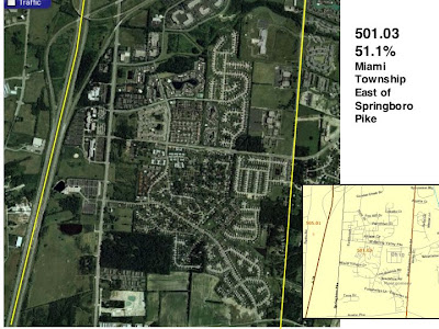
Taking a look at the top suburban tracts, what they look like from the air, and on the ground. Lots of apartment/condo clusters in these tracts, and in 501.03 some brand new starter home plats.
501.03 bears some further study as it has some early –mid 1970s multifamily, an era where the “woodsy shedsy” ski lodge style was popular. Also perhaps early examples of Planned Unit Development.
Multifamily with Corporate presence in the background. If one worked at Lexis-Nexis or Newmark one could walk or bike to work.
Tract 218 has a concentration of subsidized housing but also some nicer modern apartments.
This tract is up on the hills climbing out of the Miami Valley, so one glimpses some nice views on occasion. It’s mostly 1970s multi-famliy, with some single family out along “King Richard”. Part of West Carollton.
Except for this complex.
“Centerville Park” (pretty far from Centerville, actually) was the first apartment complex along OH 725. Bilt in the mid 1960s, it pre-dated the Dayton Mall, and most of the suburban development between Miamisburg and Centerville. Maybe a historic designation is in order? It's 40 years old or older.
Probably 1970s housing. There's actually a lot of convenience shopping close buy. Theoretically walkable, but I'll bet no one does (note the walkway or bikeway running in front of the units, left to right)
This tract is the old Village of Riverside, Overlook, and some other stuff. The concentration here in at the huge apartment complex in the heart of Riverside, built to replace WWII temporary housing.
We'll take a closer look at the Dayton high % /high # tracts later, particularly Woodland Hills and Shroyer Park.
But it seems for suburbia, for 20 and 30-something neighborhoods, one is looking at suburban apartments and condos, and maybe some starter-home plats. I didnt show Tract 301, which is also a top concentration, but it is not much different from whats shown above, except two trailer parks appear as concentrations for 21-34, as well as apartment complexes.
Thursday, March 27, 2008
On The Reading List
"[A]n original and complex explanation for the urban crisis that transformed Oakland, California, from 1945 to 1978. . . . By placing the history of Oakland and its African American community in a new theoretical framework that emphasizes suburban growth, tax revolts, and battles over land, jobs, and political power, Self has challenged historians to reconsider the way that they study postwar black urban communities."--Albert S. Broussard, Journal of American History
American Babylon traces the dialectic of suburbanization and black power in my hometown of Oakland, California. Encapsulating the postwar history of hundreds of mid-sized American cities, Robert Self's original and fascinating case study historicizes city-suburb racial segregation as a creation within living memory. We cannot heal or make sense of the nation we live in now without American Babylon."--Nell Irvin Painter, Princeton University, author of Southern History across the Color Line
I am going to follow through on those black history threads I posted earlier in the month and continue the story into the 1930s, 40s, and into modern times. The "road to Chocolate City" (tho Dayton is really Two-Tone Town). American Babylon looks like a good backgrounder and example from another small-to-midsize city
Racial Disparities by Occupation Class: Montgomery County
The exploration of racial disparities in production work leads causes one to question whether similar disparities exist across other occupations.
Again, working with the custom table feature and Census 2000 SF 4 at American Factfinder, one can generated data by occupation classification for whites and blacks across the county.
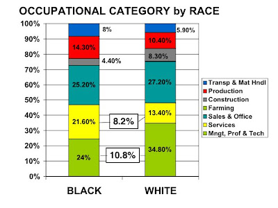
Here is a comparison. One can see that blacks lead in certain occupational groupings, particularly services (but also in production and transportation and material handling), and whites in managerial, professional and technical work (but this group does have a substantial black presence).
Within the professional & managerial group blacks have more of a concentration in community and social services and education, while whites are more in top level corporate jobs and things like engineering.
The really interesting differentials are in services.
This is the category where blacks are the most. But where are they? Services has four subcategories:
Whites, however have a very high concentration, nearly a third, in Food Service: waiters, waitresses, food prep, chefs, short order cooks, etc.
This was sort of unexpected, so let’s take a closer look at white food service workers. Graphing tracts with white food service workers, the UD area just dominates, probably due to college kids waiting tables for their tuition, so that tract is a special case.
Beyond that one can see some breaks and clusters
Which map out so:
The even spread out into suburbia , including the top tracts seems to indicate that this is probably a situation of teenagers and college kids working in fast food or other food services, since this sample is based on “working adults 16 years or over”.
Interesting to see one of the top tracts mapping out near UD: perhaps the “student ghetto”, the true off-campus student ghetto, not the “UD Houses” off Brown Street, but the area east of UD. It would be interesting to map out young adults to see if there is a geographic correlation, to see if there is indeed a second student ghetto back behind Woodland Cemetery.
We’ll take a closer look at young adults next, which will be considerable more accurate as the census does basic demographics as a 100% count, not a sample.
Again, working with the custom table feature and Census 2000 SF 4 at American Factfinder, one can generated data by occupation classification for whites and blacks across the county.
Here is a comparison. One can see that blacks lead in certain occupational groupings, particularly services (but also in production and transportation and material handling), and whites in managerial, professional and technical work (but this group does have a substantial black presence).
Within the professional & managerial group blacks have more of a concentration in community and social services and education, while whites are more in top level corporate jobs and things like engineering.
The really interesting differentials are in services.
This is the category where blacks are the most. But where are they? Services has four subcategories:
- Personal Services
- Building and Grounds Maintenance
- Protective Services
- Food Preperation & Services
- Health Care Support Workers
Whites, however have a very high concentration, nearly a third, in Food Service: waiters, waitresses, food prep, chefs, short order cooks, etc.
This was sort of unexpected, so let’s take a closer look at white food service workers. Graphing tracts with white food service workers, the UD area just dominates, probably due to college kids waiting tables for their tuition, so that tract is a special case.
Beyond that one can see some breaks and clusters
Which map out so:
The even spread out into suburbia , including the top tracts seems to indicate that this is probably a situation of teenagers and college kids working in fast food or other food services, since this sample is based on “working adults 16 years or over”.
Interesting to see one of the top tracts mapping out near UD: perhaps the “student ghetto”, the true off-campus student ghetto, not the “UD Houses” off Brown Street, but the area east of UD. It would be interesting to map out young adults to see if there is a geographic correlation, to see if there is indeed a second student ghetto back behind Woodland Cemetery.
We’ll take a closer look at young adults next, which will be considerable more accurate as the census does basic demographics as a 100% count, not a sample.
Tuesday, March 25, 2008
"This Is Dayton": Creative Region Community Pride Initiative
More information on the Creative Region Initiatives from last month. From the Dayton Most Metro website, some more information on the “Community Pride” initiative...an excerpt from a post at Dayton Most Metro:
Dayton has a huge inferiority complex …We realize that if we don't address this issue, we're behind the proverbial 8 ball.
So our vision is to reflect positive images and facts about our region back to the community so that we have tangible reasons to be very proud of Dayton (and that means the Dayton REGION, not just downtown). We are creating posters with facts & tidbits under the heading of "This is Dayton". We plan to develop a style sheet that can ultimately be used by other communities or even organizations so there is a consistent, unified look.
These posters can then be put up in vacant store fronts throughout the region, on billboards, inside and on the back of busses, at the airport, etc. These points of pride can help Daytonians see tangible reasons to feel good about our home, and show visitors our sense of community pride.
The post goes on with a call for volunteers to participate in the program, particularly people with a graphic design and marketing background to help with the layout, style sheet, production things, etc.
I am reminded a bit of that supergraphics campaign they have in Louisville with pictures of famous (ex)Louisvillians around downtown. This is both less and more than that, though.
“This Is Dayton” could be something equally simple, and a way to engage people. One does this by showing pix of people at work or doing things, with some factoid in smaller type, and a large-type “This Is Dayton” slogan
Here are a few quick takes on the concept, taking in the idea of the Dayton “region” as subject These are more like a “travel poster”, minimalist, as my taste in graphics runs more to HfG Ulm and the Swiss Style.
(I wasn’t feeling too inspired with these, so be kind)
I can see this as a positive step to fight against the endemic negativity and, at best, apathy in this area (which, to be brutally frank, gets old really fast). Though the above excerpt mentions pitching this to visitors the hard sell is going to be the locals, who are usually more negative and unappreciative than outsiders.
In any case, They are looking for volunteers, so if anyone reading this with a graphic design and/or advertising background wants to contribute, follow this link, which will take you to a discussion thread and an e-mail contact for volunteering in real-time.
Racial Disparities in the Dayton Manufacturing Sector
Black factory workers: hurt worst by the decline in manufacturing in the Dayton area?.
Conventional wisdom is that the assembly and fabrication (and textiles/clothing) category of manufacturing is most under threat for relocation to low wage labor markets. If this happens it will disproportionably impact the local Black community, leading to increased unemployment and downward mobility.
Census SF 4, which is based on a 2000 census sample, aggregates production workers into eight job classes (based on BLS Standard Occupational Classification System, production occupatons available in detail here). The census also permits the separation of these employment classifications by race, so one can if there are any discrepancies.
And there are.
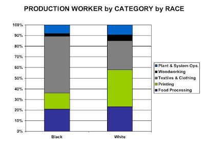
Graphing out white and black by job classification for production work, the big differences are in the Assembly & Fabrication and Metalworking & Plastics categories. Blacks working in production work are 40% in Assembly and Fabrication, the largest category for blacks compared to 20.9for whites. The base category for whites is metalworking, but this is third for blacks.
Both races are about even in the “Other “category, which is a grab-bag of production jobs. Unfortunately the census doesn’t permit further granularity for this category.
For the smaller categories, Blacks have a higher % in Textiles & Clothing and Whites are more in Printing.
So, as one can see blacks working in manufacturing could really be at threat of unemployment if Assembly & Fabrication work is going away, since such a high % of them working in production work fall into this category.
The Geography of Blacks in Assembly & Fabrication Work:
Graphing out the census tracts, highest number of A&F workers to lowest, to see if there are any breaks and clusters
And then mapping out the workforce based on the breaks suggested by the bar graph, again using 2000 data. One can see some interesting geographic clusters, in Trotwood and the Gettysburg Corridor, along Salem and Main, and the start of some concentrations in Huber, out into Englewood, and perhaps in Miami Twp.
What’s sad about this is that one can see outward mobility of black blue collar workers to better conditions in the suburbs or newer city neighborhoods, which begs the question of what are the impacts of job losses since 2000 on this upward and outward mobility, and on neighborhoods with a lot of A & F workers? (note this just looks at assembly workers).
Saturday, March 22, 2008
Today's Geography of Manufacturing
With all the interest in defense work and IT and the Creative Class Dayton still is a factory town. As of 2005 manufacturing ranked second in employment, providing 18% of the of private sector jobs in Montgomery County (ranking number two, just behind health care sector), and ranking number one in pumping money into the local economy, providing 20% of the aggregated private sector payroll in the county.
We’ve looked at some historical aspects of “The City of 1,000 Factories” (in 2005 there were 838 manufacturing establishments), so let’s look at today’s geography of manufacturing: where the plants are and where the workers live.
Sources for this post will be Zip Business Patterns (from the CenStats website) for the location of manufacturing establishment and Census 2000 SF4 @ American Factfinder for concentrations of production workers
Based on 2000 data the following map shows the census tracts with high concentrations of production workers as a % of the employed population, as well as areas with a low % of workers. Presumably the areas with a high concentration would be feeling a pinch if factory work is disappearing from the region.
"Production Worker” as defined by the Census (using BLS categories, and showing the % for Montgomery County)are these types of workers:
Zip business patterns does not provide detail on the number of employees per sector (probably for confidentiality purposes), but does tell how many manufacturing establishments are in a zip code and the size range (e.g. 1-5 employees, 500-999 employees, etc). So one can roughly locate the larger establishments (employing over 100 workers) as well as concentrations of establishments.
Using the 2000 numbers this was the geography of manufacturing establishments 8 years ago.
2005 is the most recent year for the CenStats data source, and concentrations haven’t changed much since 2000:
…the top concentrations hold about 42% of all manufacturing establishments in Montgomery County, so this is a fairly geographically concentrated economic sector.
However there has been a decrease in net number of establishments, as well as downsizing or closure of some of the larger ones.
East Dayton was the big loser, but other zip codes lost as well, including Vandalia and the area along I -75 north of the city.
Countywide there has been an increase in smaller establishments, but a decrease in the number of mid-range companies. Interestingly between 2000 and 2005 the 1000 plus size range has not changed in net number of establishments.
One can see how manufacturing has suburbanized over the years, but still with substantial concentrations within Dayton, particularly in Old North Dayton and the east side north of US 35 .
The post looked at the de-industrialization of the west side. Interestingly this area hasn’t deindustrialized that much in the 2000-2005 range as the zips comprising this area actually had a net drop of one establishment, moving from 21 to 20 establishments.
The last mass-employment 1000-employees-&-up establishments did leave or downsize, dropping from 2 in 2000 to none in 2005, showing the closure of the Delphi Wisconsin Boulevard plant and downsizing at Inland.
We’ve looked at some historical aspects of “The City of 1,000 Factories” (in 2005 there were 838 manufacturing establishments), so let’s look at today’s geography of manufacturing: where the plants are and where the workers live.
Sources for this post will be Zip Business Patterns (from the CenStats website) for the location of manufacturing establishment and Census 2000 SF4 @ American Factfinder for concentrations of production workers
Based on 2000 data the following map shows the census tracts with high concentrations of production workers as a % of the employed population, as well as areas with a low % of workers. Presumably the areas with a high concentration would be feeling a pinch if factory work is disappearing from the region.
"Production Worker” as defined by the Census (using BLS categories, and showing the % for Montgomery County)are these types of workers:
- Other (including supervisors & foremen: 34%
- Metal & plastics workers: 29%
- Assemblers & fabricators: 25%
- Textile, apparel, & furnishings workers: 4%
- Printing workers: 3%
- Food processing workers: 3%
- Plant & system operators: 1%
- Woodworkers: 1%
Zip business patterns does not provide detail on the number of employees per sector (probably for confidentiality purposes), but does tell how many manufacturing establishments are in a zip code and the size range (e.g. 1-5 employees, 500-999 employees, etc). So one can roughly locate the larger establishments (employing over 100 workers) as well as concentrations of establishments.
Using the 2000 numbers this was the geography of manufacturing establishments 8 years ago.
2005 is the most recent year for the CenStats data source, and concentrations haven’t changed much since 2000:
…the top concentrations hold about 42% of all manufacturing establishments in Montgomery County, so this is a fairly geographically concentrated economic sector.
However there has been a decrease in net number of establishments, as well as downsizing or closure of some of the larger ones.
East Dayton was the big loser, but other zip codes lost as well, including Vandalia and the area along I -75 north of the city.
Countywide there has been an increase in smaller establishments, but a decrease in the number of mid-range companies. Interestingly between 2000 and 2005 the 1000 plus size range has not changed in net number of establishments.
One can see how manufacturing has suburbanized over the years, but still with substantial concentrations within Dayton, particularly in Old North Dayton and the east side north of US 35 .
The post looked at the de-industrialization of the west side. Interestingly this area hasn’t deindustrialized that much in the 2000-2005 range as the zips comprising this area actually had a net drop of one establishment, moving from 21 to 20 establishments.
The last mass-employment 1000-employees-&-up establishments did leave or downsize, dropping from 2 in 2000 to none in 2005, showing the closure of the Delphi Wisconsin Boulevard plant and downsizing at Inland.
Wednesday, March 19, 2008
The Deindustrialization of West Dayton
The Origins of the Urban Crisis continues to inspire analyses of Dayton as a comparison. I think a key chapter in Sugrues books is Chapter 5, “The Damning Mark of False Prosperities: The Deindustrialization of Detroit" ( pages 125 through 177 of the first edition), which provides the economic context for the declining fortunes of the Detroits black community.
This chapter talks about automation and shifting business practices wiping out entire categories of jobs in the auto plants, and driving out independent suppliers and producers, changes which hit inner city Detroit particularly hard, and resulted in an increase in long-term unemployment, leading to widespread urban poverty, which also impacted neighborhood retail.
Dayton was a center for the auto sector, but was apparently much more economically diversified than Detroit, as we’ve seen by the previous discussion of unionization, which was directed at a variety of industry; from foundries to electrical equipment makers to machine builders and so forth.
Though I discussed Dayton's deindustrialization in a general sense in an earlier post I want to focus here on the west side.
As one can see by this map the west side was quite the manufacturing center, with plants mostly strung out along the rail lines radiating from the Great Miami railroad bridge.
The larger plants were associated with the auto industry: Delco, Inland, Dayton Tire. But also the large McCalls printing plant and a collection of mid-sized manufacturing establishments
Dayton industrial employment, starting in 1947, using census sources. The city was already was seeing a decline in factory work in the 1950s, which is consistent with Sugrue’s findings for inner city Detroit. Yet this was temporary, and manufacturing employment surged again in the 1960s.
The big drop happens after 1970, where there is a drastic slide into the 1980s, and then another drop into the 1990s. Though the stats don’t narrow it down to the west side, one can assume most of the manufacturing left in this era, which would correlate with an increase in long term unemployment and urban poverty. Presumably one could consult the city directories and find out when a plant closed (though employment decline could precede closure).
The fate of the labeled plants will be illustrated downthread.
By 2008 the west side was de-industrialized. Nearly all of the large manufacturing establishments are gone, and most of the mid-size ones as well. The last large auto industry plant, Inland, is threatened with closure.
Accompanying deindustrialization was the expansion of poverty across the west side. There were poor areas here in 1970 and before, but poverty expanded and deepened along with the loss of industry. One wonders if it would be possible to draw the same corellation that Sugrue did in Detroit about the connection between growth in poverty and loss of factory work?
By 2006, the west side is also experiencing large scale housing vacancy and abandonment: first the factorys go, then the people, then the houses and shops.
Though manufacturing has left there are not too many empty structures. Extensive square feet of abandoned factory like these are actually pretty rare (there was a 6 or 7 story loft building in the grassy area to the right of the Sunshine Biscuit plant):
Most of the really big plants are gone. Example is the old Moraine Products plant, which started as a munitions factory in WWI (closed in the 1990s)(Sanborn at top shows extent of the plant in 1950)
Kuhns (later Nibco) Foundry: from an extensive complex to a rubble strewn field (closed in the 1980s, I think)
Factories usually turn into vacant lots (McCall Printing, partially torn down in the 1990s or early 2000s)
….or in this case, a factory turned into a prairie (Dayton Tire closed in 1981).
The site of a big factory employing hundreds, perhaps over a thousand? Like it was never there.
Today there are few factories on the west side. A rare example is this plant on Mound Street. Interestingly, this is set in a former residential area cleared out by abandonment and urban renewal, not in an old industrial district:
Smokestack amidst a ruin field as headstone for the west side industrial graveyard.
...reminds me a bit of Si Kahns' Aragon Mill.
1. At the east end of town, at the foot of the hill
Stands a chimney so tall that says "Aragon Mill."
But there's no smoke at all coming out of the stack.
The mill has shut down and it ain't a-coming back.
2. Well, I'm too old to work, and I'm too young to die.
Tell me, where shall we go, My old gal and I?
There's no children at all in the narrow empty street.
The mill has closed down; it's so quiet I can't sleep.
3. Yes, the mill has shut down; it's the only life I know
Tell me, where will I go, Tell me, where will I go?
And the only tune I hear, is the sound of the wind
As it blows through the town,
Weave and spin, weave and spin.