This was to change with the planning for I-675.
I-675 was originally intended to provide a bypass for I-75 through traffic to avoid congestion in central Dayton. But the interstate system was an artifact of the Cold War, partially justified as a defense highway system supporting military mobility and civilian evacuation. Since a major military installation was in the area highway planning had to consider this.
The original recommended realignment didn’t do this too well, nor did a subsequent local proposal. But a notional alternative sited between Wright & Patterson fields (with access from an interbase road, or via Route 4 from I-75) might have worked, providing both military access and a bypass for I-75 through-traffic.

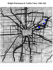
Instead planning went in another direction. Suburban interests began to drive traffic planning via the Transportation Coordinating Committee (TCC). As we’ve seen here and in previous posts traffic planning in the 1940s and 50s was dominated by cross-town and arterial/radial highways connecting central Dayton to the suburbs, driven by the central city remaining a high-employment center, as shown in this map:
 ..with Wright-Patterson remaining in the early 1960s, as in the late 1940s, one of few suburban concentrations of employment.
By 1960-61 traffic to the base appears similar to the 1940s. Big traffic streams between Dayton, Wright-Patterson, and Fairborn, seem to indicate that a lot of the base workforce was still living in the city and closer suburbs (but also recognizing that Fairborn was becoming more suburban to Dayton, too).

The flow map shows volume at half-size within the circle, so closer-in highways are fairly congested, like Smithville, 3rd, etc. Perhaps what was really happening was a suburbanizing workforce was using the road grid in Kettering and Mad River township ( like Smithville and Woodman) to travel north to Airway and Springfield/Route 4 to get to the base.
In any case a great snapshot of area traffic as it transitioned to a suburban civilization
A key document is the lost ad-hoc traffic study from 1962, which is only known via press reports. Reports indicate that the study found an “immediate need for a limited access facility”, from the base to Indian Ripple road, closer to Grange Hall Road and the county line. Here’s the recommendation diagrammed on the volume map.

Perhaps the forecast or assumption was the base workforce would continue to suburbanize during the 1960s & 70s to the east and south of Dayton. The “limited access facility” would be a cross-town (really cross-suburb) highway to the base, relieving traffic on suburban surface streets. The swing around Fairborn was needed to make the “limited access facility” part of the interstate system, and would be less complicated then routing between the bases. Besides, by this time, WSU was being located on the former “Area D” site, adding further complication to a between-the-bases alignment.

In 1965 the final I-675 alignment was set, and interchanges planned.

The phasing was to build the ‘driveway” first, not connected to the interstate system, which is a pretty clear indication of planning priorities at mid-decade. The shaded yellow areas are areas that would be accessible to the base via the first phase of I-675. I also show Huber Heights too, as it appears traffic planning was accounting for that suburb as a de-facto base housing area via improved country roads, like Chambersburg Road.

As design proceeded the military began to engineer interchanges to connect the base to the interstate, in this case for the Wright Field cantonment.@

The end result was indeed a driveway to suburbia. As shown in this aerial of the connection between Patterson Field cantonments and the interstate, the interstate replaces the old “Route 4 Expressway” as the driveway to the base; Route 4 connected the base to Dayton, while the interstate connects the base to suburbia.

One can consider the now lightly-used Route 4 as an obsolete highway, built to serve commuter traffic that has went elsewhere. Where elsewhere is a good question because, unlike the 1940s study, there is no modern mapping showing concentrations of Wright-Patterson personnel.
What there is, though, is some data showing the military and civilian base workforce from the 1930s to the 2000s. What’s noticeable is the fairly steady Cold-War era number, hovering between 20,000 and 30,000.
So what has happened was highway planning followed this population as it shifted out of the city into suburbia (maybe a chicken-and-egg thing there, too).
No comments:
Post a Comment