Autumn Equinox, the first of Fall.  ..no the trees are not changing yet. It's still summer out with the heat and humidity. But you can feel it. You can sense the change coming, the trees just about to turn, the summer overstaying its welcome and dragging out a bit, the last days before some serious cold snaps.
Daytonlogy will be featuring a Fall Almanac, inspired a bit by tracking the change in seasons, from Summer to Winter, but also a bit by that Almanac that used to be published in the Yellow Springs News (though yer humble host won't be that good in providing seasonal things).
One thing the Almanac will provide is a weekly picture every week, from the same location, to track the change in season as the leaves turn and fall. Not sure of the location yet, thinking either Woodland Cemetery or Grant Park, or maybe even this one overlooking Southern Hills
Monday, September 22, 2008
The First of Fall


Sunday, September 21, 2008
Sugarcreek Mosque Update
Back in January there was a controversy over a proposed mosque in Sugarcreek township (Greene County). The DDN reported on this, and yer humble host added his two cents here, opining on the apparent religous prejudice shown by members of a local Southern Baptist congregation in organizing opposition to the mosque, as an indicator of a certain xenophobia in this region.
There was also an apparently legitimate planning and zoning issue that got wrapped up into the controversy.
Over the course of the summer the DDN was doing a pretty good job following the issue, including a lawsuit by the Islamic Center, then a compromise solution for a smaller mosque. Oppostion dropped to generic NIMBY stuff, apparently not organized by churchgoers.
It seems that this compromise was accepted by the zoning board this past week. So a positive solution to a situation that could have gone sour.
Dayton & Vicinity: One Giant "Toxic Asset"
Spotted at the Hispanic Festival yesterday.....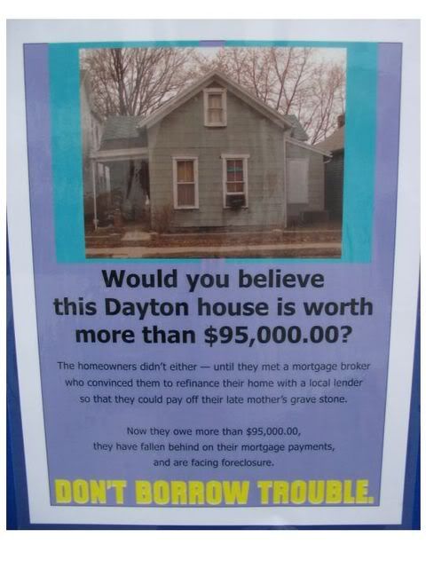
This is all high-finance. But there are houses and property behind all this, and this aspect of the crisis is not being discussed too much, as it's seen as a local issue.
Dayton was a ground zero for the foreclosure crisis. As one can see by this map showing foreclosure action a year ago the entire county was being hit by foreclosures, becoming one giant toxic asset.
Though high finance gets the Federal action, places like Dayton and its suburbs are left to sort it out the best they can.
Not even any state action to help out, a legacy of poor governance in Columbus, which actually helped continue the crisis due to the state legislature voiding Dayton and Cleveland attempts to establish local regulations for the mortgage industry.
So here we are. The vacant, foreclosed houses in the area may well have a new owner soon.

Saturday, September 20, 2008

LadyFest in Context
Starting during Urban Nights and extending through the weekend, LadyFest was probably the first public use of the Creative Incubator space (they really need to come up with a new name for this).
But what is LadyFest. Apparently this is an international movement of feminist art and music events. The Guardian, the UK broadsheet, as an excellent article on it, showing how it is a modern outgrowth of the Riot Grrrl movement of the 1990s.
"A phenomenon may be brewing. From Glasgow to Chicago, Boston to Bloomington, Indiana, women are getting together to organise arts events in the name Ladyfest. They are open to all but the ethos - "by women, for women" - is decidedly feminist. The programme ranges from fashion shows to debates on fat oppression to car mechanics workshops, but the main draw is music - and it couldn't be further from the manufactured, fame-seeking pop of the Britneys of this world."
"Ladyfest takes its name and inspiration from a festival held in Olympia, Washington, in August last year, but its ideas were informed by a much earlier movement, riot grrrl...."
More
That article was from 2001, and it's 2008, so yeah it takes awhile for things to get here, but be glad that it did get here, as this was a great little event. They even had one of my favorites, Dawn Cooksey, performing...
 ...and you have to love that thing on the floor: Dayton, the heart of Ohio, originals wanted, or maybe they are already here?
More LadyFest pix at Urban Ohio
...or at the LadyFest Dayton website.
Friday, September 19, 2008
Ingersoll Acres: Exurbia to Edge City
Ingersoll Acres was discovered by yer humble host while hunting for a shortcut around mall traffic one gloomy winter rush hour. Hidden behind the bright lights of the Dayton Mall /OH 725 retail development was this little subdivision with exceptionally large lots, on a street (Lois Circle) that connected Mad River Road and OH 725 (so not much of a shortcut).
I’ve always been curious about this place, and after getting serious about studying local urban history and geography it became a subject of inquiry. It turns out that this little plat is a good demonstration on how postwar suburban growth and evolution paralleled what happened in downtown Dayton in the prewar era, but at an auto-scale.
The study area outlined in red An Early Postwar Plat
Suburbia had already expanded well beyond Dayton city limits by the Great Depression, with 1920s plats & land speculation extending along Springboro Pike as far south as Alex-Bell Road. By this time Miamisburg and West Carollton had developed into early commuter suburbs.
This speculative activity apparently didn’t extend up the hill to the Dayton Mall area, with property apparently still being held as ag land. This early 1930s property map shows Ingersoll Acres (and a strip of property to the south of Miamisburg-Centerville Road, AKA OH 725) held by Issac Apple.
Apple’s property north of OH 725 apparently was subdivided in the 1940s, maybe after the war, with the first houses built in very late 1940s, continuing into the mid 1950s, per this map of the surviving houses
By 1954 the subdivision appears in a landscape of farmland, woodlots, orchards and ponds, near the crossroads settlement of Shanersville. On can also see the headwaters of Holes Creek draining the rolling landscape as well as limited exurban ribbon development of houses along the country roads.
Matching the USGS map with a roughly contemporaneous aerial, one can see the outlines of houses.
And an enlargement, showing the mostly rural feel of this exurban locale. One can clearly see the tree line of a branch of Holes’ Creek cutting through the development, and the houses on site
Per this plat book cut of 1960, one can see the subdivision labeled as Ingersoll Acres, as well as adjacent development. Lots aren’t shown, though, and it looks lke the corner lot at Mad River and OH 725 was retained as it’s own parcel. This might have been the original farm house as the USGS topos show a barn on the property. I-75 and the Dayton Mall dramatically transformed the landscape in this area. This transformation wasn’t instantaneous, though, with commercial development slow-rolling until the 1980s. Though the mall was directly across the street Ingersoll Acres remained residential as late as 1979, the date of this USGS topo photo-revision.

The 1980’s Boom
The 1970s was apparently a time of stagnant or slow development in Dayton. The 1980s was different, with an explosion of development in the Dayton Mall area. Ingersoll Acres was caught up in the mall area boom and transformed.
Most of the site was acquired by developers, who tore down the houses, stripped the landscape, and reassembled the parcels (right hand map shows the ages of the remaining houses, some of the older postwar housing this far south, outside of a town or village) The frontage along OH 725 was redeveloped into a mixed use strip center with some small commercial pads to the west of Lois Circle. Property deeper into the site was developed as high density residential of various types: apartments, assisted living, extended stay hotel. Nearly all of this was in place by 1988, with the last commercial build-out in the mid 1990s
 Yet there still are a handful of houses left at the rear of the site
A 2000’s aerial, showing the present situation, Ingersoll Acres as a building block of the Dayton Mall edge city
What happened here in the 1980s is identical to what happened in downtown Dayton until WWII, where the central business district expanded into adjacent residential blocks, replacing free-standing houses with various types of commercial construction, hotels, and higher density housing, yet with some individual houses surviving.
Here, the original “central business district” was the Dayton Mall, and commercial use expanded into surrounding residential and rural properties, responding to increasing property value driven by the desire by business to locate close to the mall. The difference, of course, is that development is much more spread-out and subject to single-purpose zoning.
Development in both cases was determined by the original property lines (town plat vs subdivided farm) and transportation technology (horse and street cars vs automobiles); resulting in similar changes of use: single family residential to office, retail, hotels, and high density residential.
Next, a look at what it really looks like
Ingersoll Acres on the Ground.
After maps and aeriels a virtual site visit.
We’ll move into and out of the study area, starting with the commercial development fronting Route 725, moving back into the site, and out again..
The strip center, Mad River Station, was developed by Beerman Reality, and has a feature found in the first Beerman developments of the late 1940s; second story spec office space. So this is a bit of a throwback to early postwar suburbia. This type of two-story mixed use is fairly unusual for a 1980s strip center. Pads closer to the highway are developed as freestanding buildings, which is a conventional approach. In this case it’s more retail space, but often one sees these pads developed as chain food places.

Barnes &Noble was the last structure built
The back of the strip center, with blank ground floor wall, due to this being the storage/service side of the ground floor retail
…facing the apartment complex to the rear. Proximate, but no intentional connectivity (missed opportunity).….
Water feature, Recall this was roughly on the course of that Hole’s Creek tributary.
Beyond the apartments Lois Circle narrows and one enters the rump Ingersoll Acres plat. Interesting to see striping here, for high volume traffic. The oldest surviving house, from 1949, hiding behind the trees. When this Cape Cod was built TV was still fairly new, Truman was president and the Dodgers were still playing at Ebbetts Field, and gas was 26 cents a gallon.
 1950, sort of the last gasp of the late 1930s/1940s cottage style, with “Bedford stone” trim.

1954 ranch on huge lot.
1950, according to the county auditors records. Probably one of the earliest modern “ranch style” houses in Dayton suburbia. Nice big picture window. It seems the earlier the spec ranches the better the design. Departing the remnant residential area into the 1980s/90s development.

The assisted living complex. Not shown is a water feature in front, probably a rework of an old pond on the same site. …and the extended stay hotel. This might be fairly new, as it has that big gable roof and cheapo EIFIS look to it.

Finally, a look back at what’s left of Ingersoll Acres, a survival of early postwar exurbia in the heart of a 21st century edge city.
