The DDN reports today on a landscape restoration plan for Hills & Dales.
A $4 million restoration project at the 297-acre Hills and Dales MetroPark in Kettering aims to recreate the look of the landscape when the park was a gift from John Patterson, co-founder of National Cash Register.
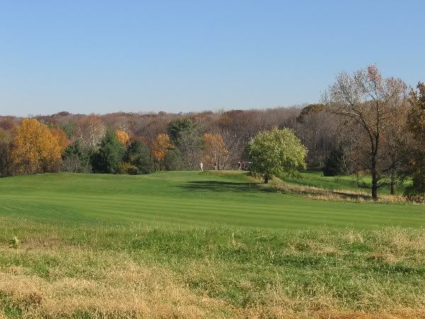
Nowadays the “park” seems like merely a big golf course with landscaped fringes. The original idea was much more ambitious.
Patterson, along with fellow industrialiss Deeds and Kettering contracted with the Olmstead firm of Boston, Mass to landscape their adjoining properties.
The intention apparently was to create an interlocking landscape system in the hill country west of Far Hills, extending from the Dayton Country Club to Rahn & Alex-Bell Roads, with a parkway (Southern Boulevard) as a connecting feature. Adjacent subdivisions estates and parks (Houk Stream)may also have designed by the Olmstead firm.
This systemic approach was akin the previous Olmstead work, such as the Emerald Necklace in Boston (though that was an urban scheme and this one rural/suburban
 The northern part was developed as Hills & Dales Park and parts of Oakwood & Kettering.
 The southern part was never completely developed, though parts became the NCR and Moraine Country Clubs and the Deeds estate.
 The interesting thing about Hills & Dales was that it was originally twice its current size, extending south of Dorothy Land. And there were little side-parkways that connected the main body of the park to Far Hills Avenue.
 Only the northern part was the gifted to the city. The southern part was later subdivided for housing.
An interesting feature was that there was a branch of the interurban line running to the park, and extending down Southern Boulevard (possibly why Southern is so wide). This is shown in the above map in red.
The idea was to improve access from the city, but with heavy auto usee cars were banned, and the park was only accessible via train.
Subsequent developement disrupted the system, and it was never completed. Enough survives, though, to give Dayton a greenbelt of estates, parks, and golf courses extending south of the city.
Vignettes from the Olmstead landscape system:


6 comments:
Frederick Law Olmsted,who developed New York's Central Park, founded the landscape architectural firm that developed Hills and Dales as well as several other projects around the Dayton area. In fact, Dayton ranks third, behind Boston and NYC, in the number of Olmsted systems around the country. This, from Ann Honious in "What Dreams We Have":
"The landscape architecture firm, Olmsted Brothers, operated from 1857 to 1950. Founded by Frederick Law Olmsted and later operated by his sons, John C. Olmsted and Frederick Law Olmsted, Jr., the firm conducted over 5,000 landscape architecture projects in forty-five states, the District of Columbia, and Canada. Except for Boston, Massachusetts, and New York, New York, Dayton has the highest number of Olmsted designs in the United States. The Olmsteds were involved in 274 designs in Ohio; 151 of these were in the Dayton area. Forty-seven of these designs were built."
Carillon Park and South Park are Olmsted projects. Another is Wright Brothers Hill, at the intersection of SR 444 and Kauffman Road, which is a part of Wright-Patterson AFB. You can read more about it at http://www.nps.gov/history/history/online_books/daav/chap12.htm . The park was dedicated on August 19, 1940, which was Orville Wright's 69th birthday. In addition to the memorial are six Native American burial mounds which are over 2,000 years old. They've never been excavated.
The local Olmstead project that intrigues me is the "Moraine Industrial Village". It is mentioned in Conover's writing, and it also appears in an online Olmstead archive.
Apparently this was to be a planned industrial suburb on property owned by the Shantz estate, roughly adjacent to the present GM plant.
I don't know if design drawings or schematics were prepared. I guess one would need to take a trip to Brookline to research the files.
But what a find if they do exist.
Jeff, this is off topic but I heard today that the Twin Valley Behavioral Health Care Campus in Belmont (behind 10 Wilmington Place, formerly the State Insane Asylum) is closing in July and it seems the buildings will be abandoned. Can you do a history of the site?
This is really interesting! Can you mention your source material? I'd love to do some further research.
Catching up:
To anonymous:
I did a pix tour of the old insane asylum over at Urban Ohio a few years ago, but not much other than the original buildings. Let me see if I can find that thread and link to it.
To Elaine:
Source material is VERY limited. The Library of Congress maintains an online database of Olmstead projects (no images), which would be a good place to generate a list.
The maps. The first map is from a history of Calvary Cemetery, but it also appears in a geology book on the Dayton area. This is what tipped me off that there was a more regional aspect to all this.
The other map, with the green tint, is Wagners Map of Dayton from the 1920s. Maps of the 20s may show some information on camps, shelters and picnic sites and such.
A real estate map from around 1930 shows the southern part of Hills & Dales owned by a Patterson, and sudividived.
You can find old maps in the Local History Room in the downtown library and in the WSU Special Collections and Archives.
Unfortunatly I do not have access to the original Olmstead designs and planting plans. Presumably these are on file at the Olmstead archives in Brookline, Mass.
For general knowleage I have read alot on the firm, and am familiar with Olmstead work in other cities, particularly the Louisville park system and the South Park system in Chicago, so know a bit of their design strategy.
This was the frame of reference that I used when considering the cluster of commissions here in Dayton.
Another source ahd info about the rail service to the park,came from a history of the C&LE Railrowd, which I got via Ohiolink.
Moraine Industrial Village is mentioned in some of the Adam Schantz Estate papers at the WSU Special Collections & Archives, and, I think, in one of the Conover history books.
Post a Comment